
The HybridForms App is optimized for digital documentation on site. Maps are an important tool for visualizing and localizing information about operations. With the extended map function »Connected Maps«, you can integrate interactive maps from multiple map providers or even multiple instances from the same provider into your forms – such as ESRI-based map systems – via map widgets.
Geoinformation is a highly specialized field, and the producers of GIS software offer their own applications for this purpose. Via map widgets, these services can be accessed directly in the HybridForms App.
Work with thematic maps that show all objects with pinpoint accuracy – and capture data directly on site with the mobile App.
Map-centric workflows: Capture location, data, additional information on objects & assets
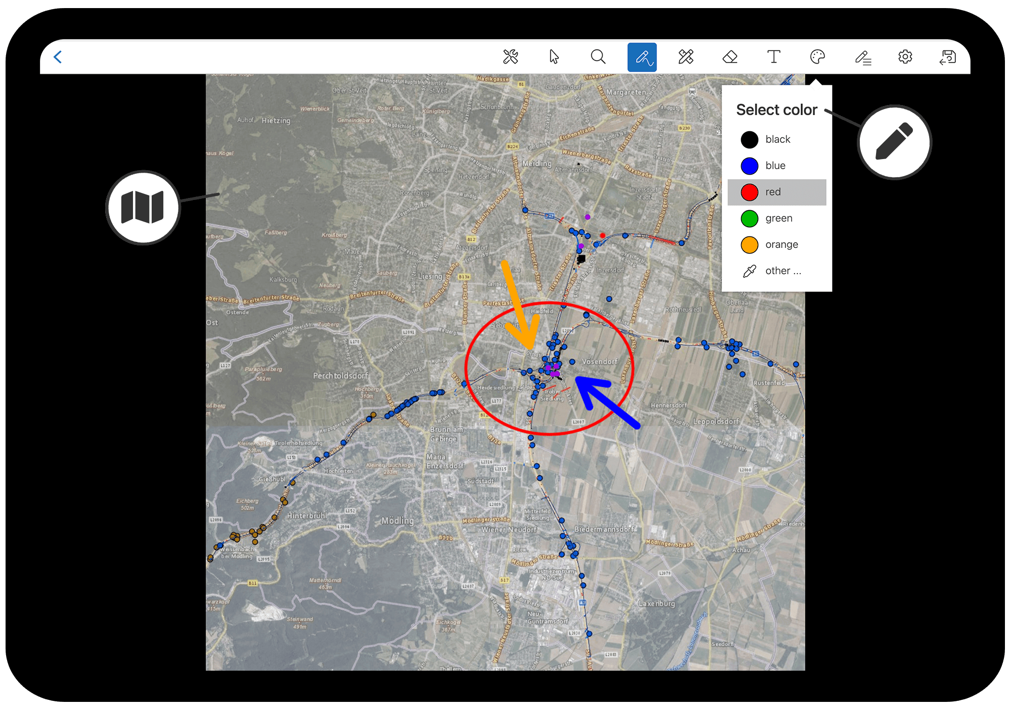
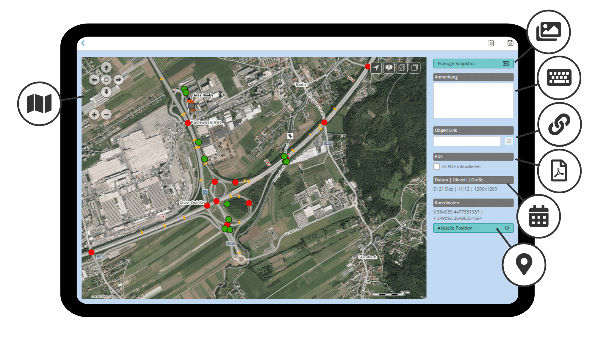
The selection of map providers available to you is displayed directly in the HybridForms App (in the example below WebOffice Map and Google Maps), as are the saved map sections (with date and time). You can create a snapshot of any selected map section, on which annotations with manual sketches and text are then possible. The sketch function offers advanced options such as font color, stroke width, shapes (such as line, rectangle, circle, arrow, dimension) or image editing (cropping). From each saved snapshot, you can also open the connected map again in the interactive view, and include snapshots optionally into the PDF export of the completed form.
Administrators can define the settings for »Connected Maps« themselves for their form templates and manage the corresponding keys/keys in the HybridForms admin interface.


Mobile documentation of operations with dynamic maps directly in the HybridForms App
Professional users who have their own GIS applications in use (for example SynerGIS MapOffice or con terra map.apps) benefit from the »Connected Maps« function – especially emergency response organizations, authorities & companies in the sector of Critical Infrastructures (CRITIS), such as energy providers, operators of road infrastructure or the police.
Connected Maps: ESRI GIS for object locations at ASFiNAG
ASFiNAG (Highway and Expressway Financing Corporation) in Austria uses the »Connected Maps« function, for example, in digital checklists for mobile maintenance (Electronic Operations Manual / EBeH) and the inspection of traffic infrastructure (IMT 2.0 Infrastructure Management). All objects and assets are precisely located in the GIS systems and are therefore clear. Users quickly recognize at a glance where an object to be inspected is located – there are no misunderstandings. Object links in the HybridForms App are used to call up the corresponding input fields for documenting the work assignments with tablets and smartphones, and the recorded data is then transferred to ProOffice Asset Management and other internal systems (such as SAP) without any time delay.
Connected Maps from HybridForms – your advantages at a glance
Integrate maps from multiple map providers or even multiple instances from the same provider into your forms.
Users with admin rights can configure the keys and settings for the map widgets directly in the HybridForms Admin App.
Professional use for users with their own GIS applications, such as authorities & organizations for emergency services and rescue services, and companies in CRITIS.